


Canadian satellite aids in hurricane recovery
Hurricane Irma, had reportedly been the strongest and most catastrophic hurricane observed in the Atlantic since Wilma in 2005 in terms of maximum sustained winds.
Satellites from several nations, including Canada, were contacted to track the progress of hurricane progress and measure the damage it caused to provide necessary information for rescue planning and recovery efforts.
For nearly two decades, there had been a global agreement between Emergency officials in the U.S. and the Caribbean.
According to official reports, International Charter on Space and Major Disasters (ICSMD) provides free access to data gathered by satellites to civil protection agencies in disaster-stricken regions and government and private space agencies.
ICSMD, a non-binding agreement, is responsible for transmission of space satellite data to relief organizations in the event of major disasters.
After Canada's Radarsat-2 passed over the hurricane hit Antigua and Barbuda, the Turks & Caicos and Dominican Republic, it sent information to the officials of these regions, reports said.
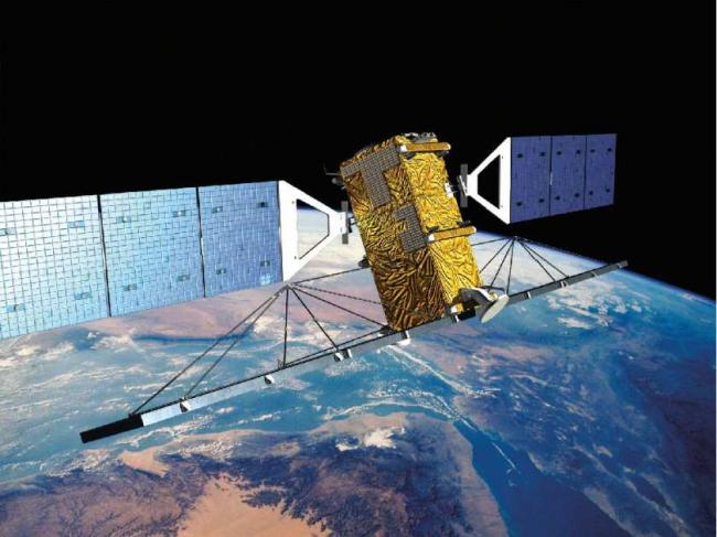
Canada's Radarsat-2, an Earth observation satellite, was launched in December 2007 for the Canadian Space Agency by Starsem, using a Soyuz FG launch vehicle, from Kazakhstan's Baikonur Cosmodrome.
Antigua and Barbuda, according to reports, are known for reef-lined beaches, rainforests and resorts, is an independent Commonwealth country situated at a point where the Atlantic and Caribbean meet.
Turks & Caicos is an archipelago of 40 low-lying coral islands in the Atlantic Ocean, a British Overseas Territory southeast of the Bahamas.
Dominican Republic, the official reports said, is a Caribbean nation that shares the island of Hispaniola with Haiti to the west.
Radarsat - 2 is owned by MacDonald, Detwiller and Associates (MDA) and operated, in part, by the Canadian Space Agency. It provides Synthetic Aperture Radar (SAR) imagery, which can see through cloud formations and monitor flooding, landslides and destruction caused by hurricanes and heavy storms.
Canada's Radarsat-2 satellite is considered as Canada's eye in the sky during natural disasters.
"Sometimes having a view from space is a definite advantage. It's instrumental in planning emergency rescues. It provides a global view," Michel Doyon, manager of flight operations at the Canadian Space Agency was quoted by the media.
 In 2000, the international charter, according to official reports, was established with the Canadian Space Agency, which on behalf of the Government of Canada coordinates all civil, space-related programs among its founding members.
Space agencies in China, Japan, Germany, the U.S. and several other countries have also signed on.
Canada had activated this agreement in May in response to flooding in Quebec and Ontario, official reports said.
The charter was invoked 37 times in 2016 and this year it has already surpassed that number.
The charter was activated yet again, since Hurricane Irma, to monitor the aftermath of Hurricane Maria and the devastating earthquake in Mexico City.
This year satellites have been engaged in monitoring forest fires, cyclones and other disasters around the globe.
(Reporting by Asha Bajaj)
Image: Canada's Radarsat-2: Wikimedia commons, MDA Robotics: Twitter
Support Our Journalism
We cannot do without you.. your contribution supports unbiased journalism
IBNS is not driven by any ism- not wokeism, not racism, not skewed secularism, not hyper right-wing or left liberal ideals, nor by any hardline religious beliefs or hyper nationalism. We want to serve you good old objective news, as they are. We do not judge or preach. We let people decide for themselves. We only try to present factual and well-sourced news.


