


 Google Map
Canada: Hiker stranded on a cliff after following fake trail on Google map, rescued by helicopter
A hiker was rescued by a helicopter from Canada's British Columbia after he was reportedly lost following a fake trail on Google map.
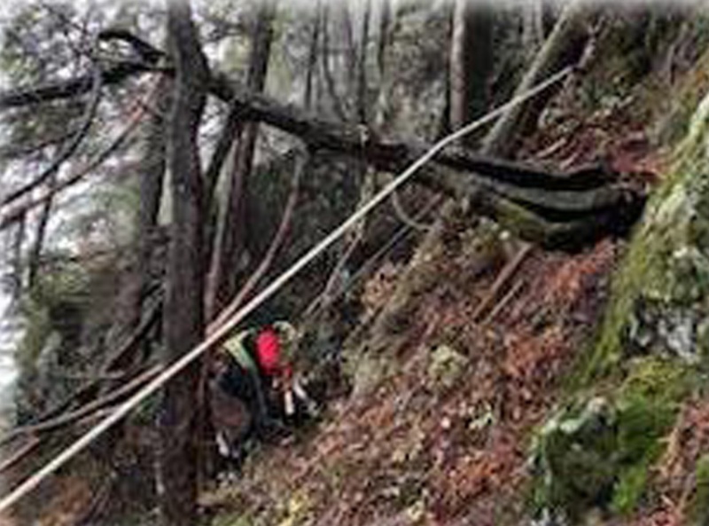
North Shore Rescue, a mountain search and rescue team based in Vancouver, wrote on Facebook: " Late Saturday afternoon, NSR helicopter and rope rescue teams responded for a hiker stranded on a cliff on the backside of Fromme. This is the third rescue NSR has conducted in this area - the last being just over a month ago."
"This individual had attempted to climb Fromme from the Kennedy Falls area. As with the previous rescue noted above, this current individual may have sought to follow a trail on Google Maps that does not exist. NSR has attempted to contact Google to have this non existent trail (north of Fromme, going towards the vicinity of Kennedy Falls) removed, however we have not received any response," read the post.
The rescue team confirmed the area in question has no trails and is very steep with many cliff bands throughout.
"The area is clearly dangerous, as it was the sight of a previous fatality," read the Facebook post.
"The team was able to locate the subject, get him in a harness, and bring him safely down to a location where he and the team could be extracted by helicopter - just before the clouds closed in and would have otherwise prevented helicopter access," the post said.
Advising hikers, the rescue team said it is simply not appropriate to navigate in the wilderness using ‘urban street map’ programs like Google Maps.
"If you are using a phone-based navigation app, consider using something specifically designed for the outdoors such as CalTopo or Gaia, pre-loaded with an appropriate wilderness topo map for the area," the team said.
"Of course, if you do use your phone for navigation (we always recommend the good old fashioned paper map and compass), be sure to carry a spare charged external battery, as mapping programs can quickly drain your phone’s battery, especially in the cold," the team mentioned.
Support Our Journalism
We cannot do without you.. your contribution supports unbiased journalism
IBNS is not driven by any ism- not wokeism, not racism, not skewed secularism, not hyper right-wing or left liberal ideals, nor by any hardline religious beliefs or hyper nationalism. We want to serve you good old objective news, as they are. We do not judge or preach. We let people decide for themselves. We only try to present factual and well-sourced news.
Support objective journalism for a small contribution.


