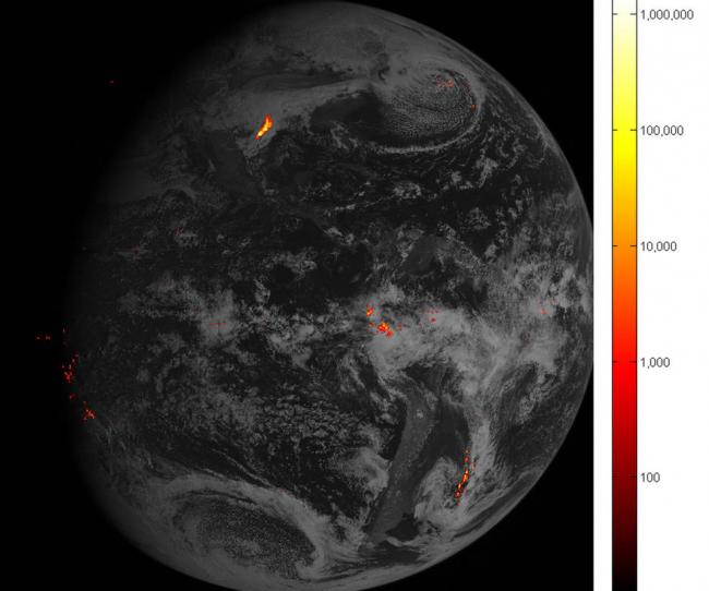
Flashy first images arrive from NOAA’s GOES-16 lightning mapper
The first lightning detector in a geostationary orbit, the Geostationary Lightning Mapper (GLM), is transmitting data never before available to forecasters.
The mapper continually looks for lightning flashes in the Western Hemisphere, so forecasters know when a storm is forming, intensifying and becoming more dangerous.
Rapid increases of lightning are a signal that a storm is strengthening quickly and could produce severe weather, read the NASA website.
During heavy rain, GLM data will show when thunderstorms are stalled or if they are gathering strength. When combined with radar and other satellite data, GLM data may help forecasters anticipate severe weather and issue flood and flash flood warnings sooner.
In dry areas, especially in the western United States, information from the instrument will help forecasters, and ultimately firefighters, identify areas prone to wildfires sparked by lightning.
Accurate tracking of lightning and thunderstorms over the oceans, too distant for land-based radar and sometimes difficult to see with satellites, will support safe navigation for aviators and mariners.
The new mapper also detects in-cloud lightning, which often occurs five to 10 minutes or more before potentially deadly cloud-to-ground strikes. This means more precious time for forecasters to alert those involved in outdoor activities of the developing threat.
NASA successfully launched GOES-R at 6:42 p.m. EST on November 19, 2016 from Cape Canaveral Air Force Station in Florida and it was renamed GOES-16 when it achieved orbit. GOES-16 is now observing the planet from an equatorial view approximately 22,300 miles above the surface of the Earth.
NOAA’s satellites are the backbone of its life-saving weather forecasts. GOES-16 will build upon and extend the more than 40-year legacy of satellite observations from NOAA that the American public has come to rely upon.
Credits: NOAA/NASA
Support Our Journalism
We cannot do without you.. your contribution supports unbiased journalism
IBNS is not driven by any ism- not wokeism, not racism, not skewed secularism, not hyper right-wing or left liberal ideals, nor by any hardline religious beliefs or hyper nationalism. We want to serve you good old objective news, as they are. We do not judge or preach. We let people decide for themselves. We only try to present factual and well-sourced news.
Support objective journalism for a small contribution.