


NASA's IMERG measures deadly West Virginia flooding rainfall
The governor of West Virginia declared a federal disaster after the worst flooding in a century. The prevalence of rough terrain in West Virginia has amplified the effects of flooding rainfall. The National Weather Service predicted that thunderstorms were going to fall in the area again today. More flash flooding with streams again coming out of their banks has been predicted.
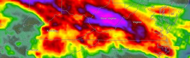
At NASA's Goddard Space Flight Center in Greenbelt, Maryland, NASA's Integrated Multi-satellitE Retrievals for GPM (IMERG) data were used to create an analysis to estimate rainfall that fell over West Virginia during the period from June 20 through 26, 2016. The IMERG analysis showed that extreme rainfall occasionally occurred during this period in an area extending from Illinois through North Carolina. Large areas of from Illinois, Indiana and West Virginia were estimated to have received rainfall totals of 320 mm(12.6 inches).
GPM is the Global Precipitation Measurement (GPM) mission. It is managed by NASA and the Japan Aerospace Exploration Agency.
Today, June 27, 2016, the National Weather Service has much of the state under a Flash Flood Watch that includes portions of northeast Kentucky, southeast Ohio. In West Virginia the watch is in effect for the following counties: Boone, Braxton, Cabell, Calhoun, Clay, Fayette, Gilmer, Jackson, Kanawha, Lincoln, Logan, Mason, Mingo, Nicholas, Pocahontas, Putnam, Raleigh, Roane, Wayne, Webster, Wirt And Wyoming. The watch is in effect until 9 p.m. EDT today. The National Weather Service said "heavy rain producing thunderstorms today and this evening combined with recent rains could cause flash flooding. Streams may rise rapidly coming out of their banks causing flooding of roads and property".
The Integrated Multi-satellitE Retrievals for GPM (IMERG) creates a merged precipitation product from the GPM constellation of satellites. These satellites include DMSPs from the U.S. Department of Defense, GCOM-W from the Japan Aerospace Exploration Agency (JAXA), Megha-Tropiques from the Centre National D’etudies Spatiales (CNES) and Indian Space Research Organization (ISRO), NOAA series from the National Oceanic and Atmospheric Administration (NOAA), Suomi-NPP from NOAA-NASA, and MetOps from the European Organization for the Exploitation of Meteorological Satellites (EUMETSAT).
All of the instruments (radiometers) onboard the constellation partners are intercalibrated with information from the GPM Core Observatory’s GPM Microwave Imager (GMI) and Dual-frequency Precipitation Radar (DPR).
Image: NASA
Support Our Journalism
We cannot do without you.. your contribution supports unbiased journalism
IBNS is not driven by any ism- not wokeism, not racism, not skewed secularism, not hyper right-wing or left liberal ideals, nor by any hardline religious beliefs or hyper nationalism. We want to serve you good old objective news, as they are. We do not judge or preach. We let people decide for themselves. We only try to present factual and well-sourced news.
Support objective journalism for a small contribution.


