


 Cyclone Yaas
Very severe cyclonic storm "Yaas" may make landfall between Paradeep and Sagar Island on May 26: IMD DG
Bhubaneswar/UNI: The cyclone “Yaas” brewing in the Bay of Bengal, is likely to turn into ‘Very Severe Cyclonic Storm’ on May 26 and make landfall somewhere between Paradeep in Odisha and Sagar Island in West Bengal.
IMD Director General Mrutunjaya Mohapatra said the very severe cyclonic storm will have wind speeds of 155 kmph to 165 kmph which might further increase to 180 kmph at the time of landfall.
He said the well-marked low pressure has already intensified further into depression and likely to move North northwestwards and intensify into a cyclonic storm by May 24.
It continues to move north-northwestwards, intensifies further and reaches the northwest bay of Bengal near West Bengal and North Odisha coasts and further intensifies into a severe cyclonic storm.
Mr Mohapatra said it is very likely to cross north Odisha – West Bengal coasts between Paradip and Sagar islands by the evening of May 26 as a very severe cyclonic storm.
The severe cyclonic storm will cause large-scale and extensive damages when it hits the Odisha – West Bengal coast on May 26.
The IMD Director said the impact of the very severe cyclonic storm will be felt more in the districts of Balasore, Bhadrak, Jagatsinghpur and Kendrapara in Odisha.
The IMD has already issued a yellow warning with heavy to very heavy rainfall from May 25 onwards at isolated places over the districts of Balasore, Bhadrak, Jajpur, Kendrapada, Jagatsinghpur, Cuttack, Puri, Khurdha and heavy rainfall at isolated places over the districts of Mayurbhanj, Dhenkanal and Ganjam.
There would be very heavy rainfall over the districts of Balasore, Bhadrak Jajpur, Kendrapada, Cuttack, Mayurbhanj and Keonjhar with isolated extremely heavy fall over the districts of Mayurbhanj, Balasore, Bhadrak and kendrapara from May 26 to May 27
Heavy rainfall is very likely to occur at isolated places over the districts of Dhenkanal, Angul, Deogarh, Khurda and Sundergarh from May 27 to May 28 next.
Met sources said 45_55 kmph gusting to 65 kmph is likely to prevail over and around Andaman & Nicobar Islands, Andaman sea & adjoining east-central and southeast Bay of Bengal from May 23 which is very likely to increase becoming 55-65 kmph gusting to 75 kmph over east central Bay of Bengal and adjoining north Andaman sea from May 23 night.
It is very likely to increase further, becoming gale wind speed reaching 65 to 75 gusting to 85 over major parts of central Bay of Bengal from May 24 forenoon for subsequent 12 hours and would decrease gradually thereafter.
Squally wind speed reaching 40-50 kmph gusting 60 kmph is very likely to prevail over north Bay of Bengal and along and off Odisha. West Bengal-Bangladesh coasts from May 24 evening.
It would gradually increase becoming 50-60 kmph gusting to 70 kmph from May 25th evening and further increase becoming gale wind speed 60-70 kmph gusting from May 26 early hours along and off West Bengal & adjoining north Odisha and Bangladesh coasts.
The wind speed increased further, becoming 90- 100 gusting to 110 kmph from May 26 forenoon and increasing thereafter till May 26 evening.
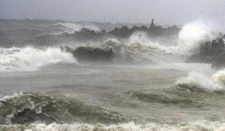
The sea condition will be rough to very rough over Andaman sea & adjoining the east-central Bay of Bengal on May 23 and 24, high to very high/phenomenal over major parts of the central bay of Bengal, north Bay of Bengal and along & off Odisha- West Bengal - Bangladesh coasts during May 24 to May 26.
The fishermen are advised not to venture into the deep sea area of central Bay of Bengal from May 23 to May 25 and into North Bay of Bengal along & off Odisha coast from May 24 to May 27. The fishermen, those who are out in the deep sea are advised to return to the coast by today.
Meanwhile, the Odisha government has issued an advisory to collectors of all coastal districts to closely monitor the situation and remain prepared to meet any water logging and localised flood-like situation including urban areas.
Support Our Journalism
We cannot do without you.. your contribution supports unbiased journalism
IBNS is not driven by any ism- not wokeism, not racism, not skewed secularism, not hyper right-wing or left liberal ideals, nor by any hardline religious beliefs or hyper nationalism. We want to serve you good old objective news, as they are. We do not judge or preach. We let people decide for themselves. We only try to present factual and well-sourced news.
Support objective journalism for a small contribution.


