NASA's IMERG measures flooding rainfall in Pakistan
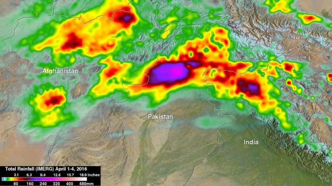
Heavy pre-monsoon rainfall moved through the area resulting in extensive damage in the Swat Valley northwest of Islamabad the capital of Pakistan, the NASA website said.
The Global Precipitation Measurement or GPM core satellite measures precipitation from space. GPM is part of NASA's Integrated Multi-satellitE Retrievals for GPM (IMERG) which uses data from multiple satellites to calculate rainfall or snowfall totals from space.
At NASA's Goddard Space Flight Center in Greenbelt, Maryland, IMERGE data were used to estimate the rainfall that occurred from April 1 to April 4, 2016. IMERG estimated that up to 308 mm (12.1 inches) had fallen in that region.
The Integrated Multi-satellitE Retrievals for GPM (IMERG) creates a merged precipitation product from the GPM constellation of satellites.
These satellites include DMSPs from the U.S. Department of Defense, GCOM-W from the Japan Aerospace Exploration Agency (JAXA), Megha-Tropiques from the Centre National D’etudies Spatiales (CNES) and Indian Space Research Organization (ISRO), NOAA series from the National Oceanic and Atmospheric Administration (NOAA), Suomi-NPP from NOAA-NASA, and MetOps from the European Organization for the Exploitation of Meteorological Satellites (EUMETSAT).
All of the instruments (radiometers) onboard the constellation partners are inter-calibrated with information from the GPM Core Observatory’s GPM Microwave Imager (GMI) and Dual-frequency Precipitation Radar (DPR).
Image credits: NASA/JAXA/SSAI, Hal Pierce
Support Our Journalism
We cannot do without you.. your contribution supports unbiased journalism
IBNS is not driven by any ism- not wokeism, not racism, not skewed secularism, not hyper right-wing or left liberal ideals, nor by any hardline religious beliefs or hyper nationalism. We want to serve you good old objective news, as they are. We do not judge or preach. We let people decide for themselves. We only try to present factual and well-sourced news.
Support objective journalism for a small contribution.