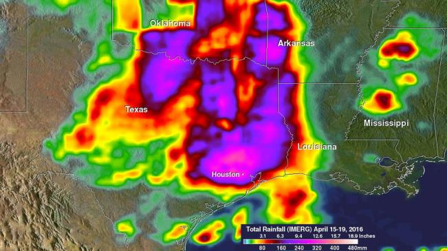
NASA's GPM looks at Texas heavy rainfall
The Global Precipitation Measurement or GPM mission core satellite provides next-generation observations of rain and snow worldwide every three hours. NASA and the Japanese Aerospace Exploration Agency (JAXA) co-manage the satellite. The data provided is used to unify precipitation measurements made by an international network of partner satellites to quantify when, where, and how much it rains or snows around the world, read the NASA website.
On Monday, April 18 the National Weather Service reported that Houston International Airport broke its all-time daily rainfall record with 9.92 inches of rain. Elsewhere in Harris County, over 17 inches of rain was recorded as of Monday evening. The main culprit was a stationary upper-level low pressure center spinning over the Central Rockies that had become detached from the main jet stream, causing it to remain in place.
At the surface, the corresponding north-south oriented frontal system, which extended from the Southern into the Northern Plains, pulled up stationary across Central Texas. The result was a steady flow of warm, moist unstable air being drawn up from the Gulf of Mexico northward across East Texas, which set the stage for and fueled numerous showers and thunderstorms across the region, including a massive thunderstorm complex that slowing moved across East Texas.
The Integrated Multi-satellitE Retrievals for GPM or IMERG is used to make estimates of precipitation from a combination of passive microwave sensors, including the GMI microwave sensor onboard the GPM satellite, and geostationary IR (infrared) data.
The data was created into an image at NASA's Goddard Space Flight Center in Greenbelt, Maryland and included IMERG rainfall estimates for the period from April 15 at 00:00 UTC (April 14 at 8 p.m. EDT) to April 19 at 08:30 UTC (4:30 a.m. EDT) for eastern Texas and the surrounding region.
IMERG showed rainfall amounts of at least 6 to 12 inches covering most of East Texas, eastern Oklahoma and the far western portions of Arkansas and Louisiana. The highest totals are located north and west of Houston and are near 15 inches. So far 5 persons are reported to have died in the area as a result of the some of the worst flooding there since Tropical Storm Allison in 2001. For updated forecasts, visit: www.weather.gov.
On Wednesday, April 20, 2016, the National Weather Service Weather Prediction Center in College Park, Maryland said "Showers and thunderstorms will continue over already soaked portions of the Texas Gulf Coast and portions of the southern Plains. The system that brought widespread heavy precipitation flooding to portions of the southern and central plains will slowly track to the east through the end of the week. "
Image Credits: NASA/JAXA/SSAI, Hal Pierce
Support Our Journalism
We cannot do without you.. your contribution supports unbiased journalism
IBNS is not driven by any ism- not wokeism, not racism, not skewed secularism, not hyper right-wing or left liberal ideals, nor by any hardline religious beliefs or hyper nationalism. We want to serve you good old objective news, as they are. We do not judge or preach. We let people decide for themselves. We only try to present factual and well-sourced news.
Support objective journalism for a small contribution.