Extremely Cyclonic Storm ‘AMPHAN’ to cross between Digha-Hatiya Islands on May 20
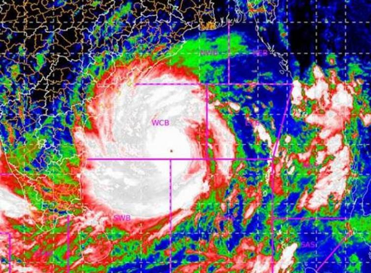
Hyderabad/UNI: The Extremely Severe Cyclonic Storm ‘AMPHAN’ (pronounced as UM-PUN) over westcentral and adjoining central parts of South Bay of Bengal moved nearly northwards with a speed of 04 kmph during past 06 hours, intensified further into a 'Super Cyclonic Storm' and lay centred at 1130 hrs on Monday over west-central and adjoining central parts of South Bay of Bengal near latitude 13.4°N and longitude 86.2 °E, about 770 km nearly south of Paradip (Odisha), 920 km south-southwest of Digha (West Bengal) and 1040 km south-southwest of Khepupara (Bangladesh).
It is very likely to move nearly northwards for some more time and then north-northeastwards across northwest Bay of Bengal and cross West Bengal – Bangladesh coasts between Digha (West Bengal) and Hatiya Islands (Bangladesh) close to Sundarbans during the Afternoon / Evening on May 20 as an 'Extremely Severe Cyclonic Storm' with maximum sustained wind speed of 165-175 kmph gusting to 185 kmph, India Meteorological Department (IMD) said in a bulletin at 1445 hours this afternoon.
The Bulletin said under the influence of the above system, on Monday, Gale wind speed reaching 210-220 gusting to 240 kmph is prevailing over west-central and adjoining central parts of south Bay of Bengal.
It is likely to increase becoming 220-230 gusting to 250 kmph over northern parts of central Bay of Bengal and adjoining North Bay of Bengal from tonight to May 19 morning, likely to increase further becoming 230-240 gusting to 255 kmph by tonight.
Squally wind speed reaching 45 to 55 kmph gusting to 65 kmph is likely to commence along and off south Odisha coast from this evening.
Sea condition will be Phenomenal over west-central and adjoining central parts of south Bay of Bengal, the bulletin added.
Support Our Journalism
We cannot do without you.. your contribution supports unbiased journalism
IBNS is not driven by any ism- not wokeism, not racism, not skewed secularism, not hyper right-wing or left liberal ideals, nor by any hardline religious beliefs or hyper nationalism. We want to serve you good old objective news, as they are. We do not judge or preach. We let people decide for themselves. We only try to present factual and well-sourced news.
Support objective journalism for a small contribution.