


NASA's AIRS captures polar vortex moving in over US
Washington, Feb 1 (IBNS): The U.S. Midwest has been gripped by the lowest temperatures it has seen in years. An unusually cold Arctic air mass, called a polar vortex, is responsible for the severe temperatures, which in many areas have plunged well below 0 degrees Fahrenheit (-18 degrees Celsius).
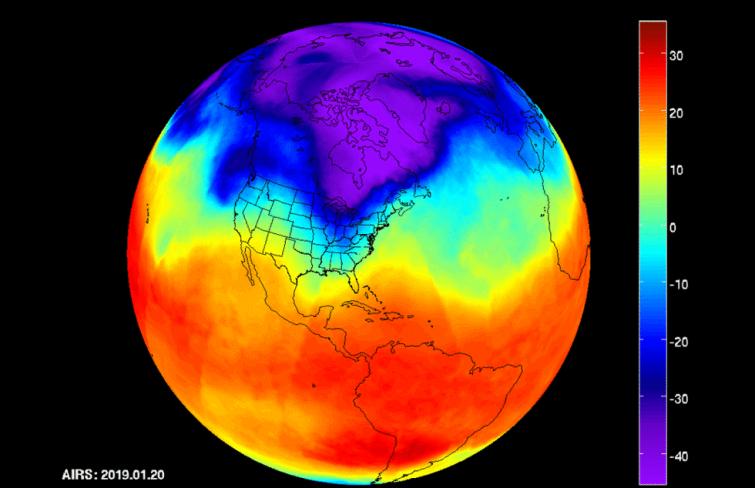
NASA's Atmospheric Infrared Sounder (AIRS) instrument aboard the Aqua satellite captured the polar vortex as it moved southward from central Canada into the U.S. Midwest from Jan. 20 through Jan. 29, read the NASA website.
The lowest temperatures are shown in purple and blue and range from -40 degrees Fahrenheit (also -40 degrees Celsius) to -10 degrees Fahrenheit (-23 degrees Celsius). As the data series progresses, you can see how the coldest purple areas of the air mass scoop down into the U.S.
The polar vortex is responsible for a number of deaths, disruptions to services, and energy outages in the affected areas.
AIRS, in conjunction with the Advanced Microwave Sounding Unit (AMSU), senses emitted infrared and microwave radiation from Earth to provide a three-dimensional look at Earth's weather and climate. Working in tandem, the two instruments make simultaneous observations down to Earth's surface.
With more than 2,000 channels sensing different regions of the atmosphere, the system creates a global, three-dimensional map of atmospheric temperature and humidity, cloud amounts and heights, greenhouse gas concentrations and many other atmospheric phenomena.
Launched into Earth orbit in 2002, the AIRS and AMSU instruments are managed by NASA's Jet Propulsion Laboratory in Pasadena, California, under contract to NASA. JPL is a division of the Caltech in Pasadena.
Image Credit: NASA/JPL-Caltech AIRS Project
Support Our Journalism
We cannot do without you.. your contribution supports unbiased journalism
IBNS is not driven by any ism- not wokeism, not racism, not skewed secularism, not hyper right-wing or left liberal ideals, nor by any hardline religious beliefs or hyper nationalism. We want to serve you good old objective news, as they are. We do not judge or preach. We let people decide for themselves. We only try to present factual and well-sourced news.
Support objective journalism for a small contribution.


