NASA looks at midwest rain and melting snow that contributed to flooding
Washington, Feb 27 (IBNS): Much of the U.S. Midwest has received above normal precipitation this winter. A NASA rainfall analysis provided a look at the precipitation that contributed to current flooding.
Recent heavy rainfall and melting snow has caused flooding from eastern Texas to Michigan.
Major flooding is expected along the Ohio River in Illinois and Kentucky. On Feb. 23, the National Weather Service noted that several locations along the Ohio River near Louisville were under flood warnings. Parts of Arkansas and Indiana are also preparing for major flooding.
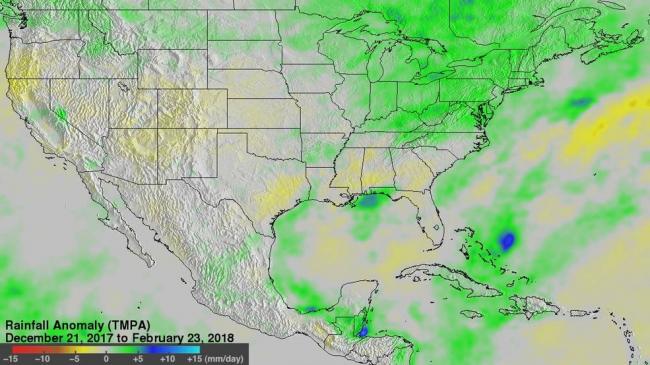
At NASA's Goddard Space Flight Center, in Greenbelt, Maryland, a rainfall anomaly analysis was made by comparing rainfall data compiled during the twelve year period from 2001 to 2012 to "near real-time" Multi-satellite Precipitation Analysis (TMPA-RT 3B42RT) data collected from December 21, 2017 to February 23, 2018.
This TMPA rainfall anomaly analysis indicated that parts of the upper Midwest have had 5 mm (0.2 inches) of precipitation per day above normal so far this winter.
Much of the U.S. southwest and west were found to have lower than normal amounts of precipitation.
Experimental Multi-satellite rainfall anomaly analyses have been automatically calculated and those data shared with the public for over a decade.
The National Weather Service noted on Feb. 23,
"The heavy rainfall that began last week and continued over the weekend has brought widespread flooding to the central and southern U.S., from the Gulf Coast to the Great Lakes. Numerous river systems will remain in flood stage this week. Another round of rainfall is forecast across the Lower/Mid-Miss. and Tenn. River Valleys Tuesday into Wednesday, which will exacerbate the ongoing flood threat."
Credits: NASA/Hal Pierce
Support Our Journalism
We cannot do without you.. your contribution supports unbiased journalism
IBNS is not driven by any ism- not wokeism, not racism, not skewed secularism, not hyper right-wing or left liberal ideals, nor by any hardline religious beliefs or hyper nationalism. We want to serve you good old objective news, as they are. We do not judge or preach. We let people decide for themselves. We only try to present factual and well-sourced news.
Support objective journalism for a small contribution.