Typhoon Meranti hits China
According to reports, winds have shattered windows on high buildings located in the area where the typhoon made the landfall.
"The winds and rain got extremely loud after 3 a.m. The cracking sound of windows and tree branches were also scary. The power went out in the shop for several times," Su Binglin, a night-shift shop assistant at a 24-hour convenient store, was quoted as saying by Xinhua.
Schools in many parts of China were closed on Wednesday as a precautionary measure.
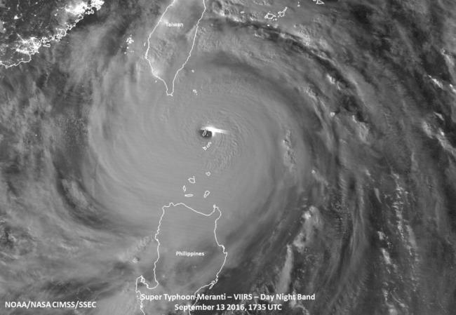
Typhoon Meranti hit the Philippines island of Itbayat as NASA-NOAA's Suomi NPP satellite passed overhead and captured infrared and night-time imagery of the powerful storm.
On Sept. 14 the Visible Infrared Imaging Radiometer Suite (VIIRS) instrument aboard the NASA-NOAA Suomi NPP satellite captured an infrared image of Typhoon Meranti as it hit the island of Itbayat in the Luzon Strait.
VIIRS infrared data shows temperature and revealed that cloud tops north and northwest of the center were colder than minus 70 degrees Fahrenheit (minus 56.6 degrees Celsius).
Cloud top temperatures that cold indicate storms stretching high into the troposphere and have been shown to generate heavy rain.
Suomi NPP also provided a night-time image at the same time when Super Typhoon Meranti as it hit the island of Itbayat. Itbayat is the largest island in the province of Batanes, northern Philippines.
"The waxing gibbous moon, which was 93 percent full provided quite a bit of illumination for the Day Night Band on VIIRS to observe quite a number of features, including (tropospheric) gravity waves emanating from the very well defined eye, mesovorticies within the eye itself, which were only visible in the Day-Night band and not the infrared band, and a lone lightning "streak" near the eyewall itself," said William Straka III of the University of Wisconsin-Madison, who created the images.
VIIRS collects visible and infrared imagery and global observations of land, atmosphere, cryosphere and oceans.
At 5 a.m. EDT (0900 UTC) Meranti brought maximum winds of 178.4 mph (155 knots/287.1 kph) as it moved south of Taiwan.
By 11 a.m. EDT (1500 UTC) Typhoon Meranti had maximum sustained winds near 125 knots (143 mph/ 231.5 kph). It was centered near 23.5 degrees north latitude and 118.8 degrees east longitude. That's about 176 nautical miles west-southwest of Taipei, Taiwan. The storm was moving to the northwest at 12 knots (13.8 mph/22.2 kph).
Meranti is moving toward mainland China where it will make landfall in Guangdong and Fujian in southern part of the country later in the day on Sept. 14 (EDT). The storm is then expected to dissipate inland.
Credits: NASA/NOAA/NRL
Support Our Journalism
We cannot do without you.. your contribution supports unbiased journalism
IBNS is not driven by any ism- not wokeism, not racism, not skewed secularism, not hyper right-wing or left liberal ideals, nor by any hardline religious beliefs or hyper nationalism. We want to serve you good old objective news, as they are. We do not judge or preach. We let people decide for themselves. We only try to present factual and well-sourced news.


